Thanks to the brilliant minds of The Friends of Lake Jesup, we are now in discussions of a potential mitigation bank.
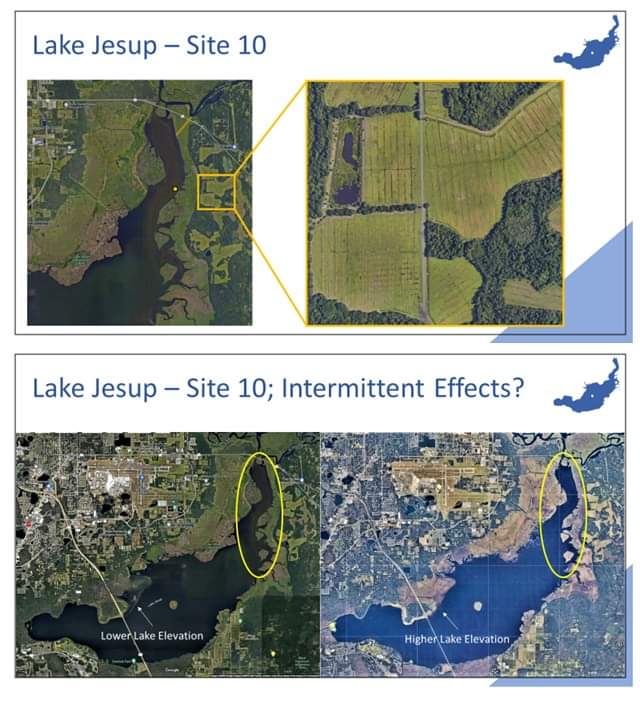
“Site 10” is owned by The City of Sanford, this 1,000+ acre parcel would be an excellent preservation/restoration project to clean up Lake Jesup! I am currently working with the Former Mayor of Sanford and environmental consultants to look into restoring this property to the benefit of Lake Jesup. I am excited to collaborate on this possible win-win solution for our environment and the economy.
Site Details:
3.2.3 CITY OF SANFORD “SITE 10” FACILITY The Sanford Reuse Land Application Facility (“Site 10”) is located on the northeastern shore of Lake Jesup. Site 10 is approximately 1,868 acres, of which 1,252 acres are in the Lake Jesup Basin. Agriculture (pastures and citrus groves) and wetlands are the major land uses on the site. The City of Sanford NPDES permit allows discharge to a permitted capacity slow-rate reuse system on Site 10, including reclaimed water storage on site in two holding ponds. The water from the ponds is used to irrigate the hay fields and citrus groves on the site. In addition, the previous permit identified Site 10 as an area where land application of residuals occurred and this application began in May 1997 (CDM, 2007). Residuals application on Site 10 was discontinued in 2009 and the current permit prohibits land application of residuals on Site 10. As noted above, the TMDL only accounted for the surface runoff loads from the site and did not estimate the TP loads associated with the reuse water and residual application activities. During the BMAP process, the stakeholders requested that the total loading from Site 10 be determined. To help accomplish this, two studies were conducted: one by CDM as a consultant for the City of Sanford (City of Sanford Site 10 Data Evaluation) and one by the FDEP Ground Water Protection Section (Ground Water Assessment Report for Site 10). CDM and FDEP used two different models with different assumptions and EMC values, which resulted in different loading estimates. Details on both of these studies can be found in Appendix G. The purpose of the CDM analysis was to model runoff from the site with revised land use information. This analysis estimated that the site has a stormwater loading of 883 lbs/yr of TP or 573 lbs/yr of TP with BMPs in place (CDM, 2007). The FDEP assessment focused on shallow ground water conditions on Site 10. The purpose of this assessment was to provide current information for shallow groundwater in the hay field areas that drain to Lake Jesup. The TP concentrations from the monitoring wells ranged from non-detect to 5.3 mg/L, with a median for the four hay fields of 0.76 mg/L. A portion of the TP concentration was also attributed to natural conditions in the area (FDEP, 2008).
The 632 lbs/yr of TP that was calculated as the surface runoff load (refer to Section 2.5.2.2) was included in the allocation table as the starting point load for Site 10, which provided the basis for the required reduction. Since the load from the reclaimed water and residual applications were not originally considered in the TMDL, the 3,489 lbs/yr of TP from these sources was not included in the BMAP allocations. However, the City of Sanford has proposed projects to reduce the loading from these sources on Site 10 and also monitoring to determine water quality improvements. The projects to address these loads are discussed in Section 4.1.2 and the proposed monitoring efforts are discussed in Section 5.1.3.4. In the next cycle of the TMDL, the monitoring data will be used to provide a better estimate of the total load from Site 10 and this information will be incorporated into the TMDL and allocations.


